
Epektasis Maps of the Region
The first set of maps on this page are from Le Monde Diplomatique produced in 2004.
The second set of maps and text on this page are from BBC News Online which explores the conflict by comparing maps of the region over time.
Stay updated
Join epektasis.net on your favourite social network or media.
-

Map of the Partition 1947-1949
Réalisé par Marie-Sophie Keller, Emmanuelle Pauly, Peggy Pierrot, Philippe Rekacewicz, Philippe Rivière et Florence Touret. Tous Droits Reserves.
-
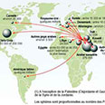
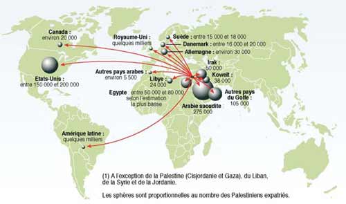
Map of the Palestinian Diaspora
Réalisé par Marie-Sophie Keller, Emmanuelle Pauly, Peggy Pierrot, Philippe Rekacewicz, Philippe Rivière et Florence Touret. Tous Droits Reserves.
-

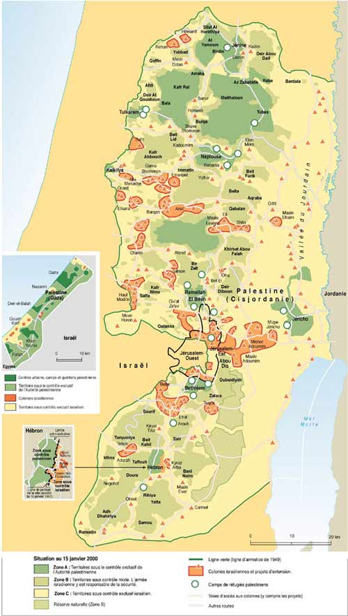
Map of the present Palestinian State (2004)
Réalisé par Marie-Sophie Keller, Emmanuelle Pauly, Peggy Pierrot, Philippe Rekacewicz, Philippe Rivière et Florence Touret. Tous Droits Reserves.
-
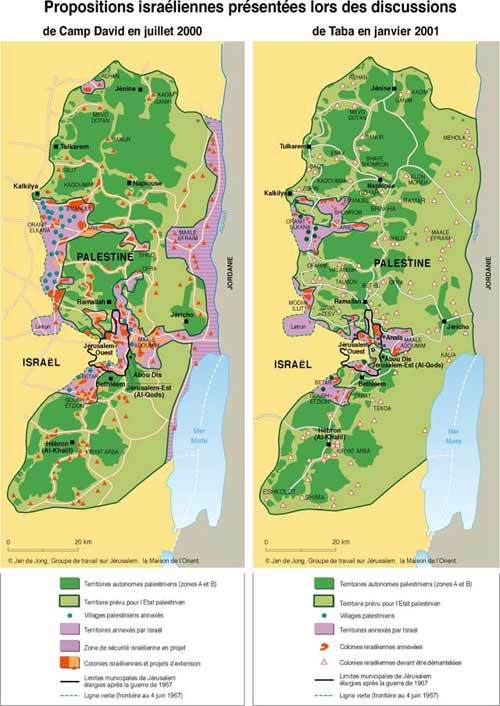
Map of Israeli Proposals of 2001
Réalisé par Marie-Sophie Keller, Emmanuelle Pauly, Peggy Pierrot, Philippe Rekacewicz, Philippe Rivière et Florence Touret. Tous Droits Reserves.
-
Map of the Geneva Proposals for the Region of 2003
Réalisé par Marie-Sophie Keller, Emmanuelle Pauly, Peggy Pierrot, Philippe Rekacewicz, Philippe Rivière et Florence Touret. Tous Droits Reserves.
-

Map of the Geneva Proposals for Jerusalem of 2003
Réalisé par Marie-Sophie Keller, Emmanuelle Pauly, Peggy Pierrot, Philippe Rekacewicz, Philippe Rivière et Florence Touret. Tous Droits Reserves.
-

Map giving an introduction to the Israeli- Palestinian conflict
At the heart of the Israeli-Palestinian conflict is a dispute over land and borders. The geography of the conflict revolves around the three territorial units of Israel, the West Bank and Gaza, defined by armistice lines drawn after a war in the region in 1948. Since then, military action, settlement and population growth have also shaped the situation on the ground.
-

Map of British control: Sykes-Picot
The Sykes-Picot agreement was a secret understanding concluded in 1916 between Great Britain and France, with the assent of Russia, for the dismemberment of the Ottoman Empire. The agreement was not implemented, but it established the principles for the division a few years later of the Turkish-held region into the French and British-administered areas of Syria, Iraq, Lebanon and Palestine.
-

Map of British control: Mandate Palestine
Palestine - comprising what are now Israel, the West Bank, Gaza Strip and Jordan - was among several former Ottoman Arab territories placed under the administration of Great Britain by the League of Nations. The mandate lasted from 1920 to 1948. In 1923 Britain granted limited autonomy to Transjordan, now known as Jordan.
-

Map showing Israel founded: UN partition plan
The United Nations General Assembly decided in 1947 on the partition of Palestine into Jewish and Arab states, with Jerusalem to be an international city. The plan, which was rejected by the native Arabs, was never implemented.
-

Map showing Israel founded: Armistice
War broke out in 1948 when Britain withdrew, the Jews declared the state of Israel and troops from neighbouring Arab nations moved in. After eight months of fighting an armistice line was agreed, establishing the West Bank and Gaza Strip as distinct geographical units.
-

Map showing the Six-Day War: Before the war
From 1948 to 1967, the West Bank, including East Jerusalem, was ruled by Jordan. During this period, the Gaza Strip was under Egyptian military administration. Israeli troops captured Egypt's Sinai peninsula during the 1956 British, French and Israeli military campaign in response to the nationalisation of the Suez Canal. The Israelis subsequently withdrew and were replaced with a UN force. In 1967, Egypt ordered the UN troops out and blocked Israeli shipping routes - adding to already high levels of tension between Israel and its neighbours.
-

Map showing the Six-Day War: After the war
In a pre-emptive attack on Egypt that drew Syria and Jordan into a regional war in 1967, Israel made massive territorial gains capturing the West Bank, Gaza Strip, Golan Heights and the Sinai Peninsula up to the Suez Canal. The principle of land-for-peace that has formed the basis of Arab-Israeli negotiations is based on Israel giving up land won in the 1967 war in return for peace deals recognising Israeli borders and its right to security. The Sinai Peninsula was returned to Egypt as part of the 1979 peace deal with Israel.
-

Map showing Jerusalem: Before 1967
The armistice line drawn at the end of the 1948 war divided Jerusalem into two. Between 1949 and 1967, Israel controlled the western part of Jerusalem, while Jordan took the eastern part, including the old walled city containing important Jewish, Muslim and Christian religious sites.
-
Map showing Jerusalem: After 1967
Israel captured the whole of Jerusalem in 1967 and extended the city's municipal boundaries, putting both East and West Jerusalem under its sovereignty and civil law. In 1980 Israel passed a law making its annexation of East Jerusalem explicit. The city's status remains disputed, with Israel's occupation of East Jerusalem considered illegal under international law. Israel is determined that Jerusalem be its undivided capital, while Palestinians are seeking to establish their capital in East Jerusalem.
-

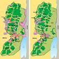
Map of the West Bank: Palestinian- controlled areas
Since the 1993 Declaration of Principles resulting from the Oslo peace process, there have been several handovers of land to differing degrees of Palestinian control. Currently 59% of the West Bank is officially under Israeli civil and security control. Another 23% of it is under Palestinian civil control, but Israeli security control. The remainder of the territory is governed by the Palestinian National Authority - although such areas have been subject to Israeli incursions during the recent intifada.
-
Map of the West Bank: Population centres
The areas of Palestinian Authority control are mainly located in Palestinian urban areas – the population centres where much of the fast-growing population lives. These take up about 8.5% of the West Bank. About 2.2 million Palestinians live in the West Bank, together with about 400,000 Israeli settlers - including those who live in East Jerusalem. About 6.7 million people live in Israel, of whom about 1.3 million are Israeli Arabs.
-

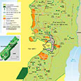
Map of the West Bank: Israeli settlements
Since 1967, Israel has pursued a policy of building settlements on the West Bank. These cover about 2% of the area of the West Bank and are linked by Israeli-controlled roads. There are also large tracts of Israeli-controlled land designated as military areas or nature reserves.
-

Map of the West Bank: Israeli checkpoints
Military checkpoints on West Bank roads allow Israel to monitor and control travel in much of the West Bank. During the recent Palestinian intifada, Israeli troops have also encircled and staged incursions into population centres and severely restricted the movement of Palestinian civilians. In 2002, Israel began building a security barrier near the north-western edge of the West Bank.
-

Map of the Gaza Strip: Population
Gaza, one of the most densely populated tracts of land in the world, is home to 1,226,000 Palestinians, about 33% of whom live in United Nations-funded refugee camps. Gaza is also home to about 5,000 Jewish settlers.
-

Map of the Gaza Strip: Settlements and security
Israeli settlements cover or control about 30% of the Gaza Strip. Israel controls all external borders and crossing points and some roads in Gaza – although in May 2003 it handed control of the main north-south highway back to Palestinian security forces.


Viewing maps
Click an item to view a larger version of the map.
Navigate back to the map gallery by clicking the "close" button on the right hand side of the image.
You can also simply toggle from map to map using the forward and backward arrows on the left hand side of the image.
Further information on each image appears directly below.